9 Beautiful Waterfall Hikes in Washington
This post may contain affiliate links. When you make a purchase through an affiliate link on this site, I may earn a small commission at no additional cost to you. Read full disclosure here.
Want to see some waterfalls on your next hike in Washington? Look no further than this list of waterfall hikes in the state!
I love going on waterfall hikes in Washington because those all-too-often cloudy days can’t ruin the view at the end of the trail.
These waterfall hikes will take you all over Washington, from the Seattle area up to the San Juan Islands and over to the Olympic peninsula.
While there are even more waterfall hikes in Washington than what is listed here, I’ve selected some of the best as these trails are generally well-maintained and easy to navigate.
These waterfall trails range in difficulty level as well. I’ve listed them from shortest to longest distance.
Scan through the list to find a difficulty level that matches your abilities, or look forward to a variety of waterfall hikes as you cross each one off your list!
Once you’ve picked your waterfall hike of choice make sure to pack a bag with day hike essentials before you head out.
Happy hiking!
1. Cascades Falls
- Distance: 1.6 miles roundtrip
- Elevation gain: 137 feet
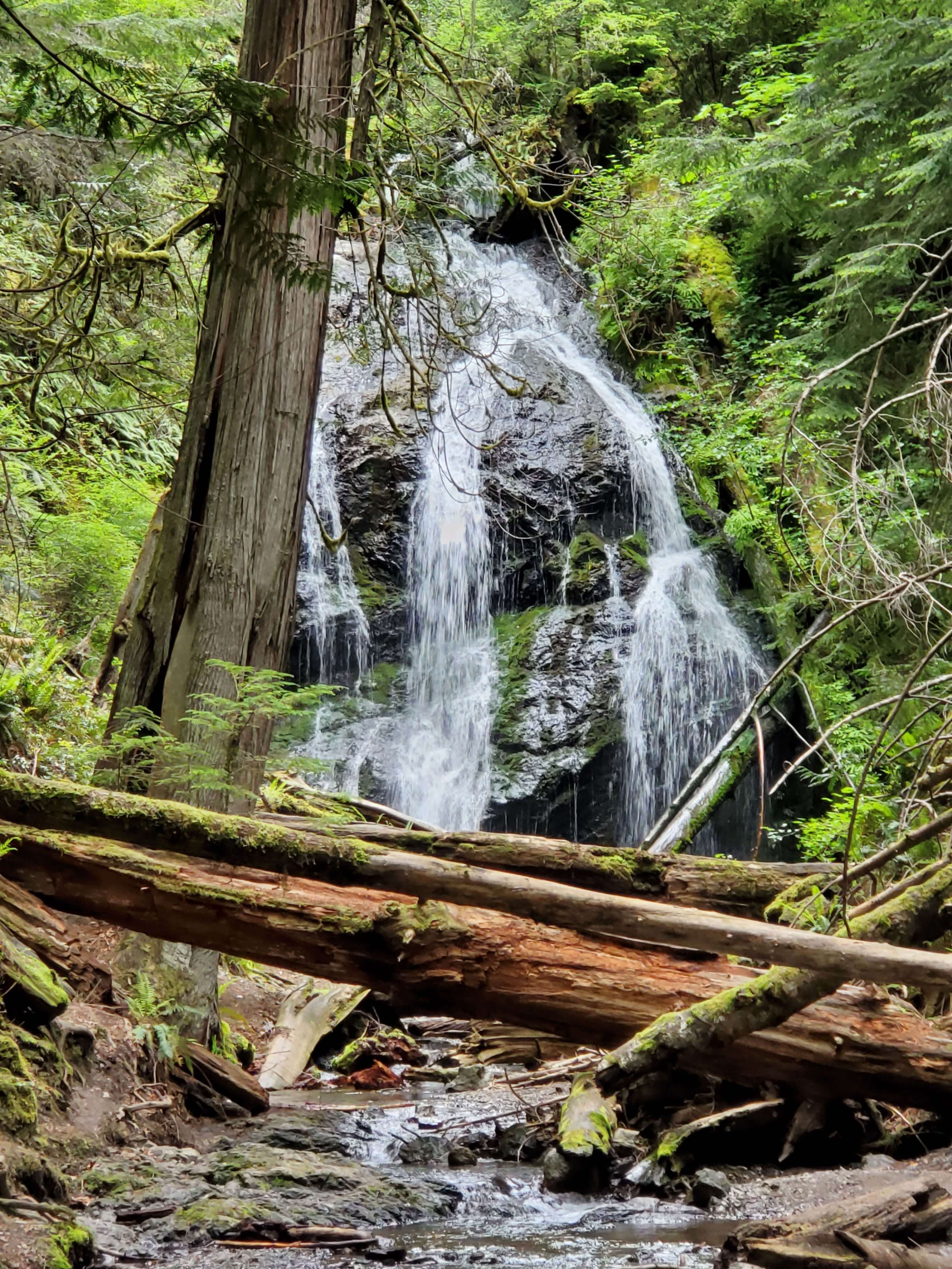
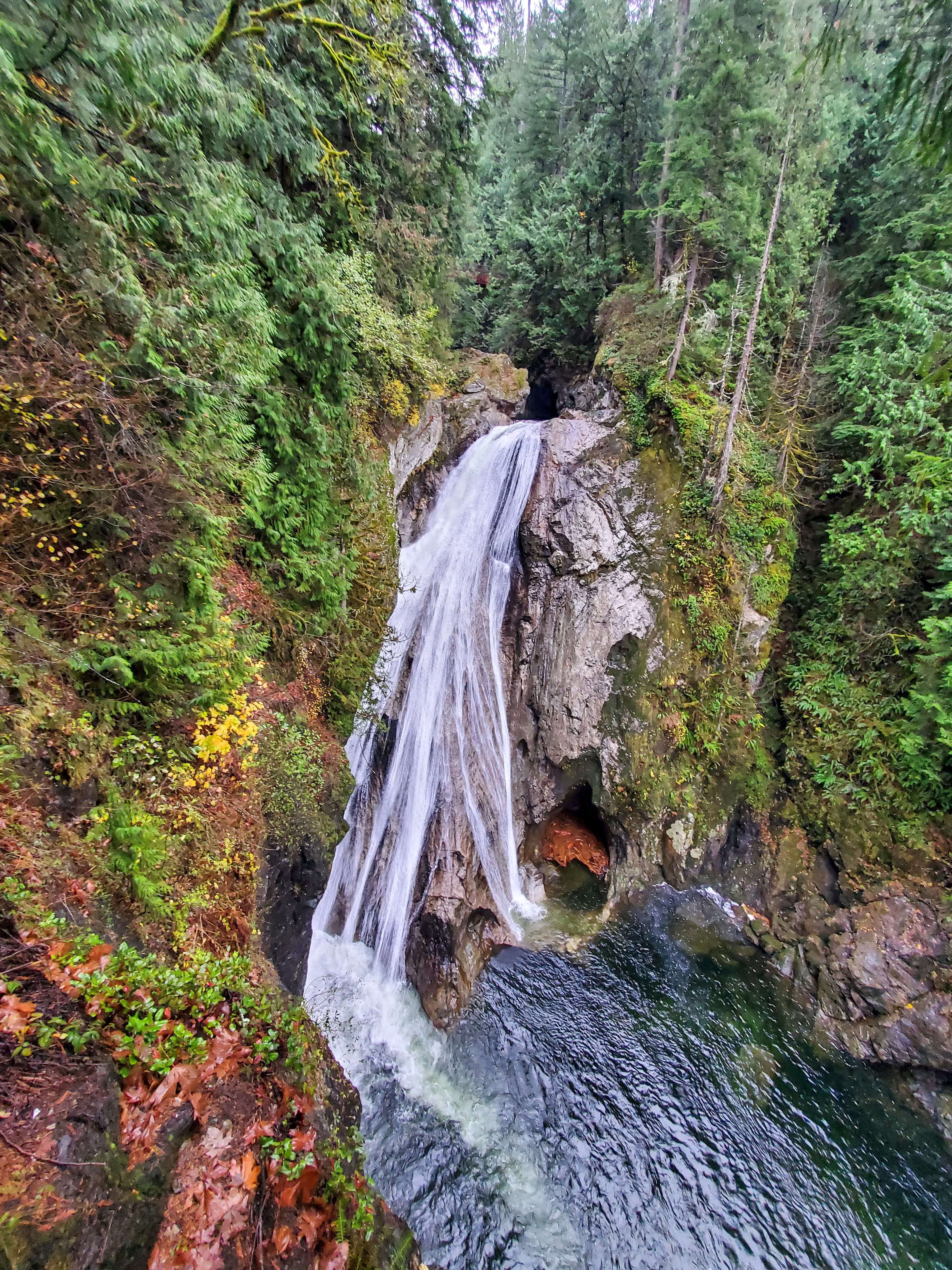
The Cascade Falls Trail is located in Moran State Park on Orcas Island. Orcas Island is one of the San Juan Islands off the northwest coast of Washington.
Despite being named the Cascade Falls Trail, the path actually takes you to four waterfalls (Rustic, Cavern, and Hidden Falls are the others).
Cascades Falls is one of the first of the four waterfalls you’ll see on the hike. However, it is perhaps the most impressive waterfall on the trail. At 40 feet, Cascades Falls is the tallest waterfall in the San Juan Islands.
Cascades Falls has both an upper and lower view point. Make sure to check them both out before you continue on to the remaining waterfalls!
In order to park in Moran State Park you’ll need to purchase a Discover Pass. If you don’t already have one, a day pass or annual pass can be purchased once you’re at the park.
Related: 8 Fantastic Hikes On Orcas Island: A First-Timer’s Guide
2. Sol Duc Falls
- Distance: 1.6 miles roundtrip
- Elevation gain: 200 feet
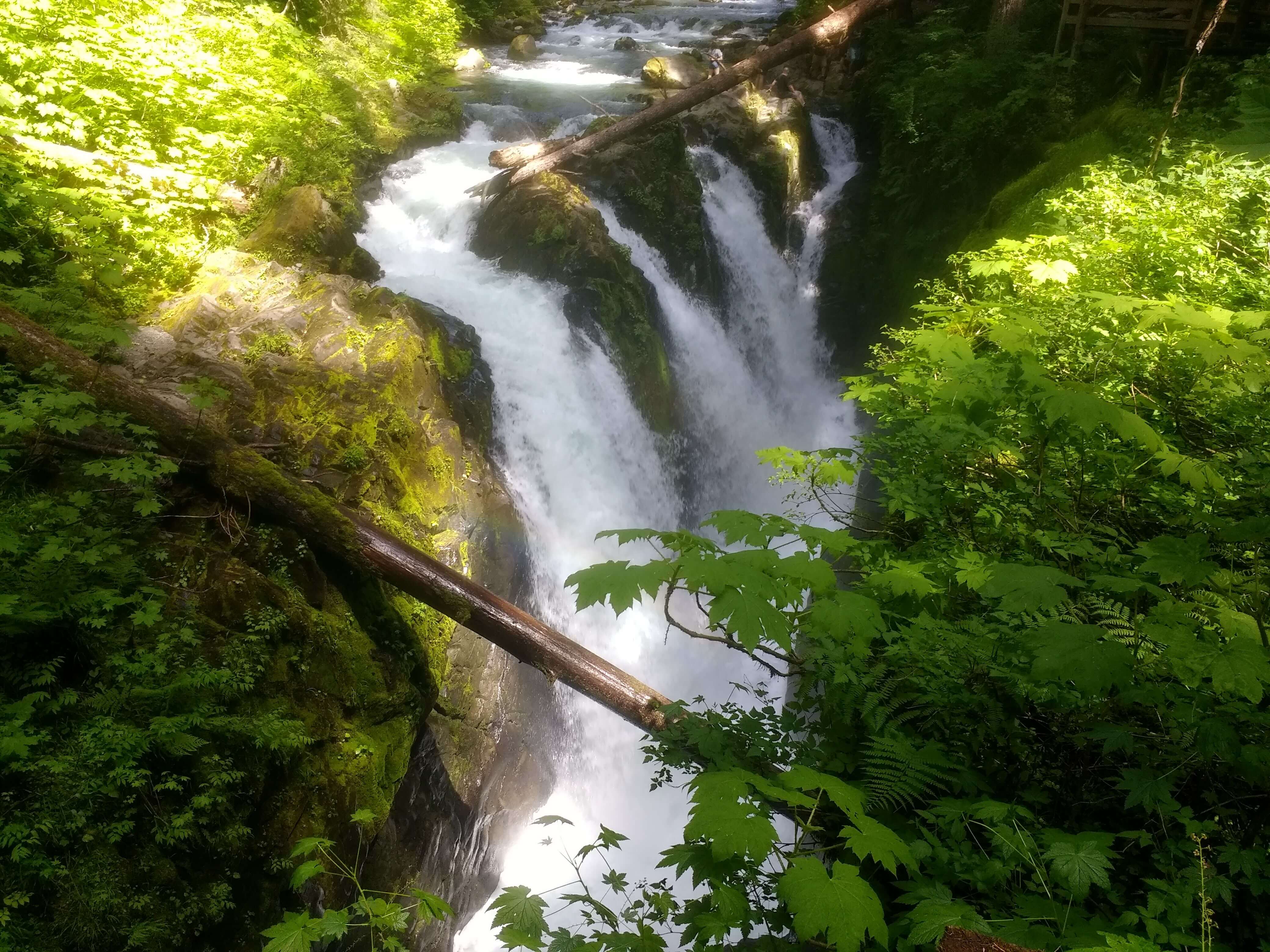
Sol Duc Falls can be found in Olympic National Park on the Olympic peninsula of Washington state.
This 48-foot tall waterfall cascades down in multiple sections as if several waterfalls were placed side by side.
The trail is fairly level, making it a great choice for families with kids who are visiting this national park.
At the end of the trail is plenty of space to walk around and view Sol Duc Falls from various angles.
The trailhead is located in the Sol Duc area of the park, past the Sol Duc Hot Springs Resort at the end of Sol Duc Road.
You’ll need to pay Olympic National Park’s entrance fee in order to access Sol Duc Falls.
Related: The Camper’s Complete Guide To Visiting Olympic National Park
3. Marymere Falls
- Distance: 1.8 miles roundtrip
- Elevation gain: 500 feet
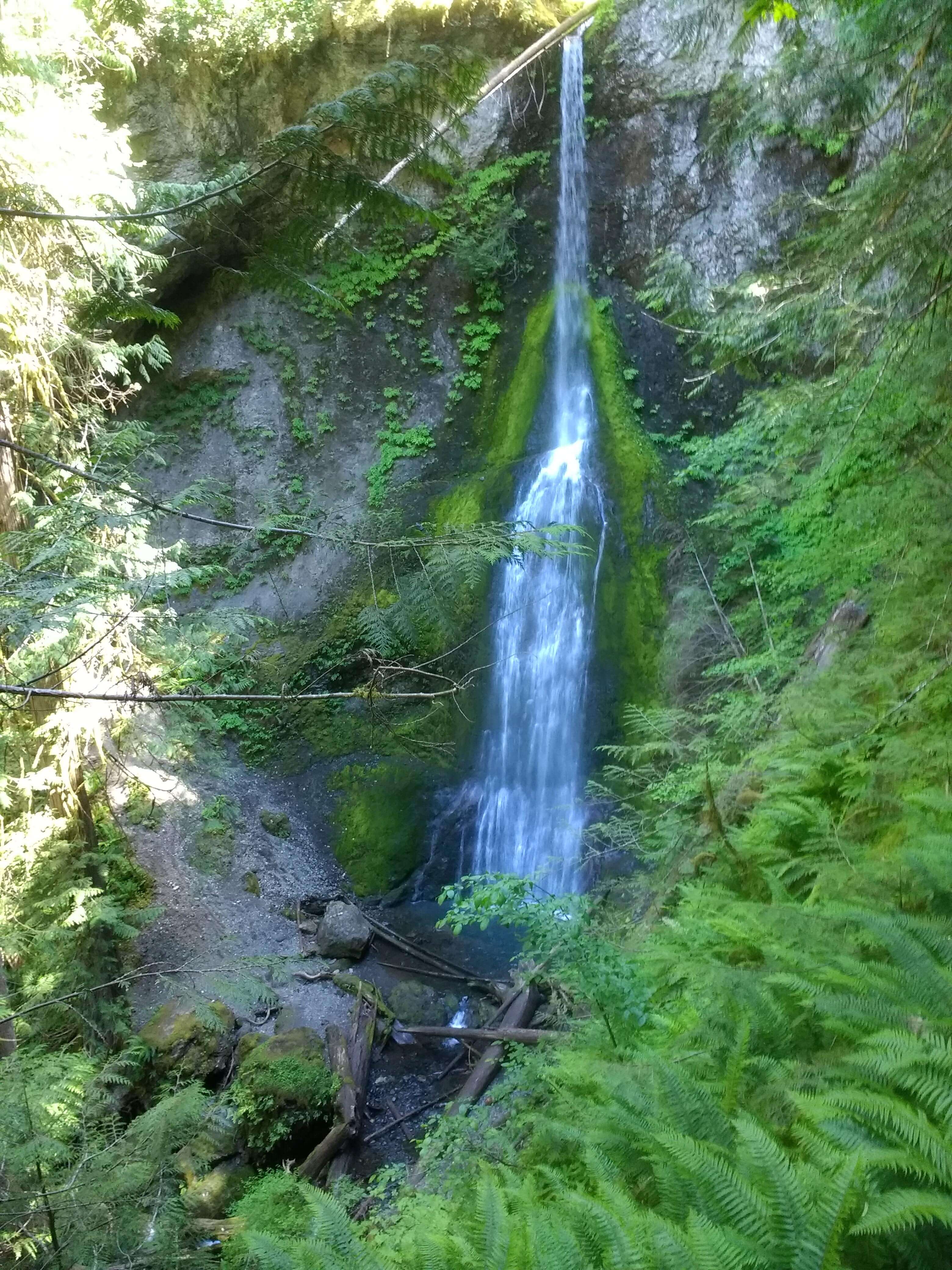
Marymere Falls is another waterfall hike in Olympic National Park.
The hike to this 90-foot waterfall is one of the more popular trails in the park. Try getting to the trailhead early if you want to beat the crowd!
The Marymere Falls Trail is easy to access as the beginning is located not too far off the main highway that runs through the park (Highway 101).
The parking area is along the southern shore of Lake Crescent. After your hike, consider grabbing a bite to eat at the Lake Crescent Lodge or just admiring the lake before you get back in your car.
It takes about 45 minutes to drive between Marymere Falls and Sol Duc Falls if you want to hike to both of these waterfalls in one day.
Related: The Ultimate List Of Waterfall Quotes & Captions For Instagram
4. Franklin Falls
- Distance: 2 miles roundtrip
- Elevation gain: 400 feet
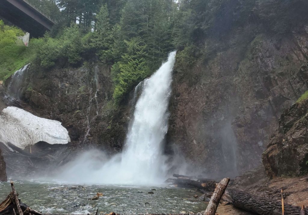
The trail to Franklin Falls can be found along I-90 near Snoqualmie Pass in western Washington.
This short and sweet waterfall hike makes for a great family-friendly outing.
There is a parking area near the trailhead, but if there are no parking spaces left, keep driving for another half a mile to another larger parking lot (and keep in mind that this will add another mile to your trip). Make sure to display your Northwest Forest Pass before setting out for the trail.
Once you’re on the trail, enjoy this easy route that parallels a thin branch of the Snoqualmie River.
The trail ends at the gushing, 70-foot Franklin Falls. You may want to bring a rain jacket even on a sunny day if you want to walk up close to the waterfall.
If you’re interested in hiking this trail in the winter, keep in mind that the road to Franklin Falls may be closed due to snow.
Related: 17 Best Easy Hikes In Washington State (According To A Local)
5. Twin Falls
- Distance: 2.6 miles roundtrip
- Elevation gain: 500 feet
The Twin Falls trail is in Olallie State park near North Bend, Washington.
Since this trail is in a state park you’ll need to purchase a Discover Pass. If you don’t already have one, a day pass or annual pass can be purchased from a kiosk at the trailhead.
This trail leads hikers to a set of waterfalls (Upper and Lower Falls). Although Lower Falls is the real show-stopper, Upper Falls aren’t too far beyond and are worth viewing even if just for the chance to spend more time out in nature.
The beginning of this trail runs parallel to the Snoqualmie River, so you don’t have to wait to get your dose of beautiful water features on this hike.
Once you ascend the first hill you’ll come to a bench that offers a glimpse of the Lower Falls as you rest. But you’re not finished yet – this isn’t the final viewpoint!
Eventually you’ll reach a fork in the trail where a set of stairs will lead you down to your right. These stairs will take you down to view the Lower Falls up close.
If you choose to view the Upper Falls as well, climb back up the stairs to return to the fork and continue on until you reach a bridge. On the bridge you’re standing above the Lower Falls; from here you can view the much smaller Upper Falls to one side and down into the river on the other side.
You can turn around and retrace your steps at this point, though the trail does continue on for about another mile if you want to keep hiking. At this point the trail intersects with the Palouse to Cascades Trail (formerly called the Iron Horse/John Wayne Pioneer Trail), which runs over 250 miles across the state of Washington.
Related: 5 Must-Do Hikes In North Bend (Easy To Hard)
6. Silver Falls
- Distance: 3 miles roundtrip
- Elevation gain: 300 feet
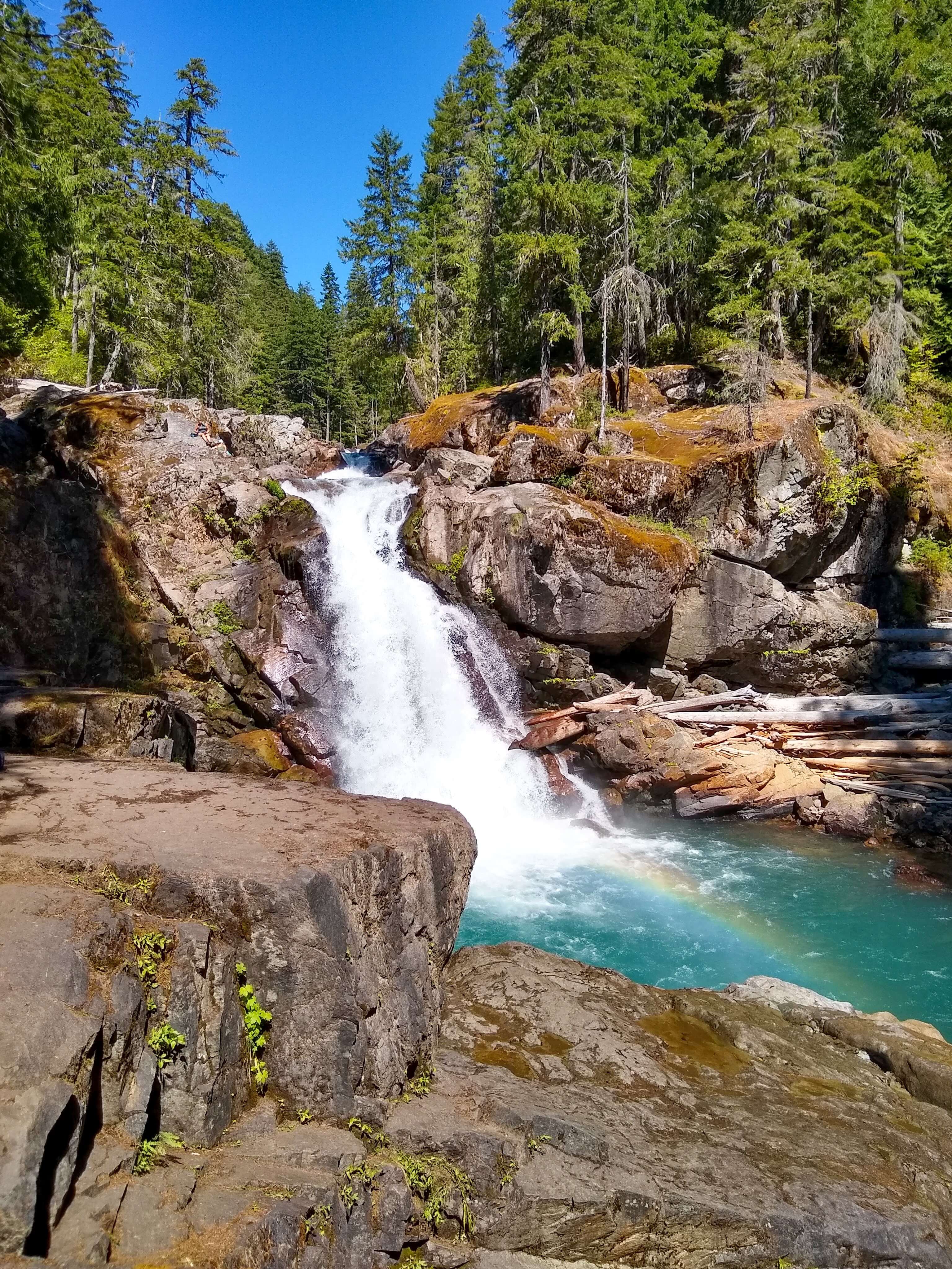
Silver Falls is located in the Ohanapecosh area of Mount Rainier National Park.
I found this hike to be the perfect way to end our camping trip to the national park: it required just enough effort to satisfy our desire to hike, but was still short enough that we had time to pack up camp beforehand and drive back to our home in Seattle afterwards.
This trail starts in the Ohanapecosh Campground; if you aren’t camping there, look for signs for the day use parking area. Once you’re parked, you can actually start this hike from one of two trailheads: either next to campsite B-2 in Loop B (near the visitor center) or near the campground amphitheater.
Once you reach the 40-foot waterfall there is plenty of space to relax and enjoy a nice picnic lunch near the falls. Just be very careful walking around the rocks because they can get slippery.
I hiked back to the Ohanapecosh Campground on the same leg of the trail I used to come in to the falls, but you could complete this hike as a loop instead if you cross the bridge below the falls and continue the trail from there.
Related: Best Easy Day Hikes In Mount Rainier National Park
7. Bridal Veil Falls
- Distance: 4 miles roundtrip
- Elevation gain: 1,000 feet

Bridal Veil Falls is located near Index, Washington along Highway 2 in western Washington.
The trail to Bridal Veil Falls starts off at the Lake Serene trailhead. You’ll need a Northwest Forest Pass to park here
The path to the falls is the same as the trail to Lake Serene for about a mile and a half until you reach the fork that leads to the falls. (Note that the distance listed above only applies to hiking to the waterfall, not the lake.)
As you approach the waterfall, cascading water runs across the trail so make sure to wear shoes that you don’t mind getting wet.
At the end of the trail, look up to see all 100 feet of Bridal Veil Falls cascade down and continue to run on down the mountain beyond you.
8. Wallace Falls
- Distance: 5.6 miles roundtrip
- Elevation gain: 1300 feet
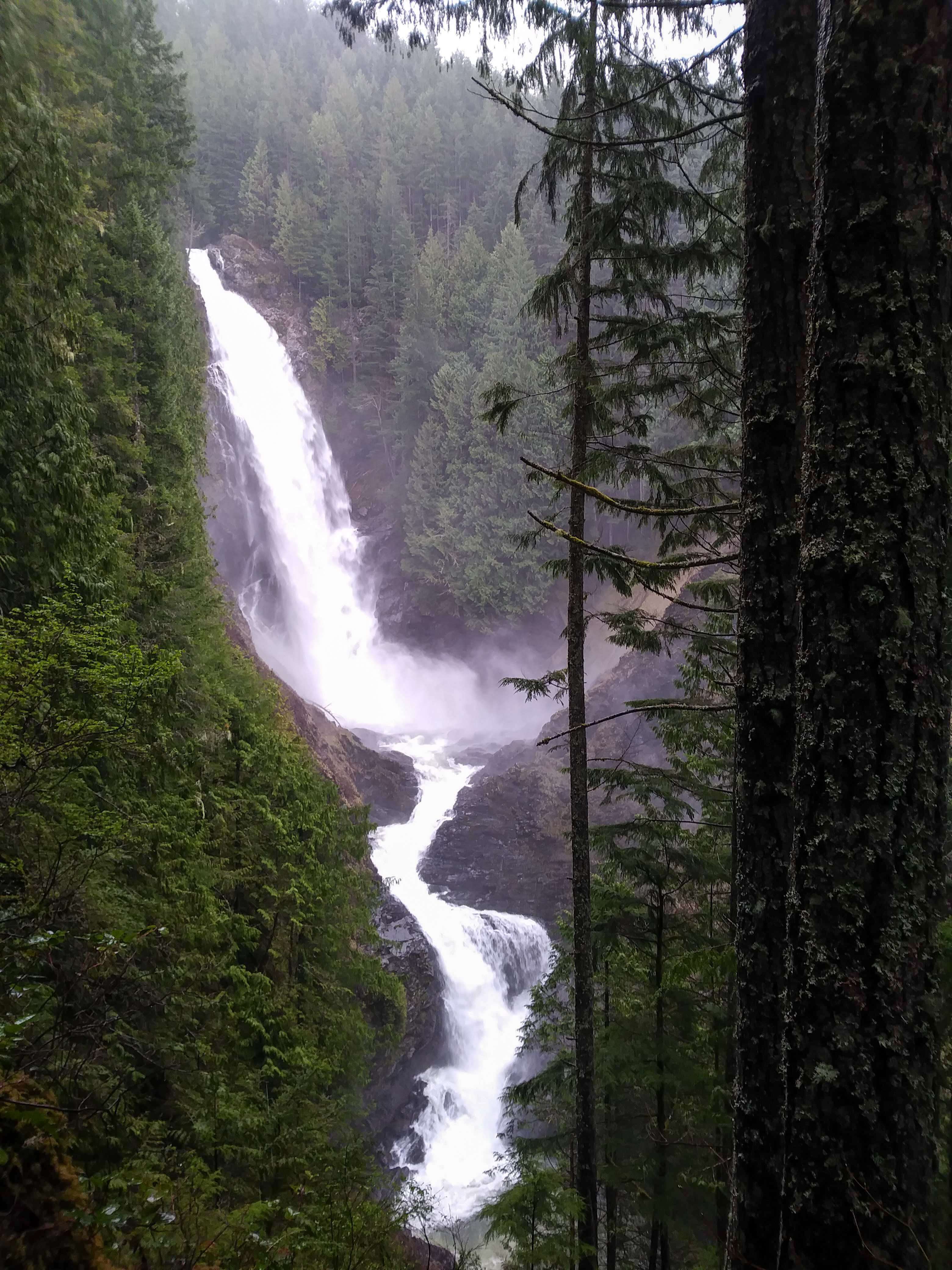
Wallace Falls is in Wallace Falls State Park. Like Bridal Veil Falls, Wallace Falls is also located along Highway 2 in Washington.
You’ll need to purchase a Discover Pass to access this trail as well; it can be purchased at the parking lot if you don’t have one in advance.
Once you’re on the trail, follow signs for the Woody Trail to head to Wallace Falls.
You’ll see three sections of Wallace Falls along the Woody Trail: lower, middle, and upper falls.
Lower falls is the shortest of the three falls. There is a nice covered picnic area at this viewpoint if you want to stop for a snack or lunch on the way up or down.
Middle falls is the most iconic section of this Washington gem. It is the tallest of the three falls with a drop of 265 feet.
The hardest stretch of the trail is the hike up to reach the upper falls. For this reason some hikers choose to turn around after the middle falls, but the upper falls are definitely worth the extra difficulty.
9. Teneriffe Falls
- Distance: 5.6 miles roundtrip
- Elevation gain: 1585 feet
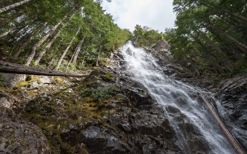
The trail to Teneriffe Falls is near North Bend, Washington (only 15 minutes away from Twin Falls listed above).
To access the trail to Teneriffe Falls, drive to the Mount Teneriffe trailhead.
A Discover Pass is required to park here. Don’t want to drive there? If you live in Seattle, take a shuttle to Mount Teneriffe using Trailhead Direct during its operating season (roughly spring through October).
Start off on the Mount Teneriffe trail, but veer off when you see the sign for Teneriffe Falls Trail.
The steepest part of the trail is at the end, but it’s worth it. Make it to the end and you’ll be rewarded with a waterfall so tall you can hardly capture it all in one picture!
Looking for more trails in Washington? Check out these related articles:
- 17 Best Easy Hikes In Washington State (According To A Local)
- 18 Great Fire Lookout Hikes In Washington
- 12 Amazing Lake Hikes In Washington
- 8 Fantastic Hikes On Orcas Island: A First-Timer’s Guide
- 6 Spectacular Sunrise & Sunset Hikes Near Seattle
- 5 Must-Do Hikes In North Bend (Easy To Hard)
As always, enjoy the outdoors responsibly. Leave no trace on all of your adventures.