5 Must-Do Hikes in North Bend (Easy to Hard)
This post may contain affiliate links. When you make a purchase through an affiliate link on this site, I may earn a small commission at no additional cost to you. Read full disclosure here.
North Bend, WA is situated amid many fantastic hiking trails.
The city is sandwiched between Rattlesnake Mountain Scenic Area and Mount Si Natural Resources Conservation Area. Olallie State Park and Middle Fork Snoqualmie Natural Resources Conservation Area are nearby, too.
When I lived in Seattle, North Bend was one of my go-to destinations for day hikes. The trails in this area are less than an hour from Seattle, making these hikes some of the best trails near the city.
I associate North Bend with some of the most challenging trails I’ve ever done. But don’t worry – there are hikes for all skill levels in the area.
I put together this list of hikes in North Bend so you can spend less time researching and more time on the trail. The list is organized from easiest to hardest hike.
Ready to pick a trail? Here are 5 must-do hikes in North Bend.
1. Twin Falls
- Distance: 2.6 miles roundtrip
- Elevation gain: 500 feet
The Twin Falls trail is in Olallie State Park.
Since this trail is in a state park you’ll need to purchase a Discover Pass. If you don’t already have one, a day pass or annual pass can be purchased from a kiosk at the trailhead.
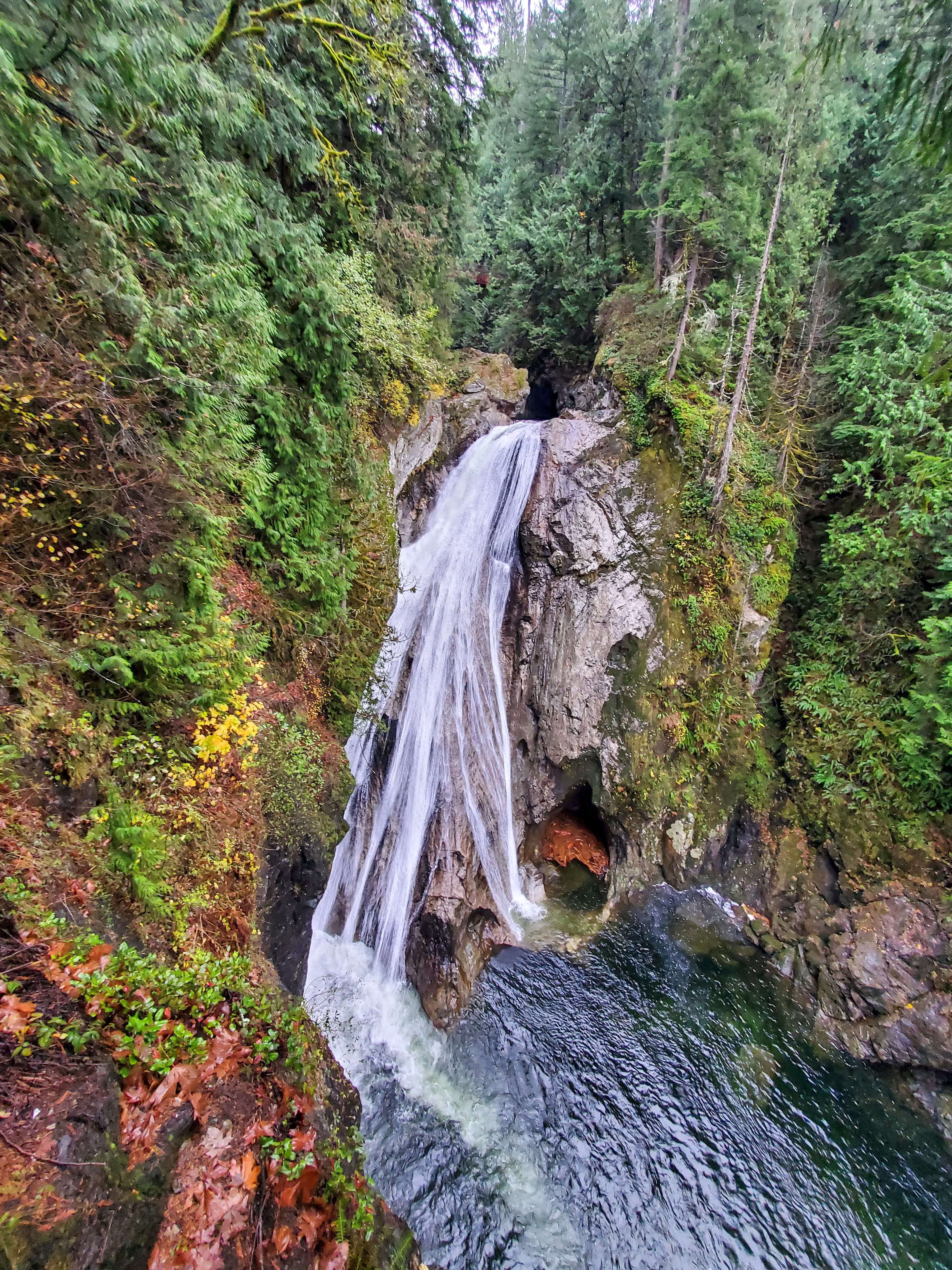
This trail leads hikers to a set of waterfalls (Upper and Lower Falls). Although Lower Falls is the real show-stopper, Upper Falls aren’t too far beyond and are worth viewing even if just for the chance to spend more time out in nature.
The beginning of this trail runs parallel to the Snoqualmie River, so you don’t have to wait to get your dose of beautiful water features on this hike.
Once you ascend the first hill you’ll come to a bench that offers a glimpse of the Lower Falls as you rest. But you’re not finished yet – this isn’t the final viewpoint!
Eventually you’ll reach a fork in the trail where a set of stairs will lead you down to your right. These stairs will take you down to view the Lower Falls up close.
If you choose to view the Upper Falls as well, climb back up the stairs to return to the fork and continue on until you reach a bridge. On the bridge you’re standing above the Lower Falls; from here you can view the much smaller Upper Falls to one side and down into the river on the other side.
You can turn around and retrace your steps at this point, though the trail does continue on for about another mile if you want to keep hiking. At this point the trail intersects with the Palouse to Cascades Trail (formerly called the Iron Horse/John Wayne Pioneer Trail), which runs over 250 miles across the state of Washington.
2. Rattlesnake Ledge
- Distance: 4 miles roundtrip
- Elevation gain: 1,160 feet
Rattlesnake Ledge is a classic hike in North Bend.
It’s one of the most popular trails in the area because it’s less than an hour from Seattle and it’s a solid, easy hike that challenges you just enough for pretty views.
When I say it’s popular, I mean it’s super popular. One time I got there at 7am on a Saturday morning and we got one of the last parking spots – and it’s a huge parking lot. But, it’s must-do hike that every Washington hiker should experience at least once.
This trail will take you to three ledges with viewpoints. To make this hike even easier, you could just soak up the views from the lowest ledge before returning to the trailhead.
3. Teneriffe Falls
- Distance: 5.6 miles roundtrip
- Elevation gain: 1,585 feet
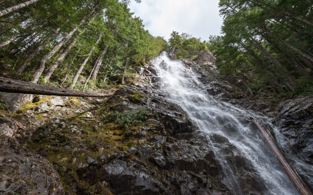
There are certainly easier waterfall hikes in Washington, but the trail to Teneriffe Falls makes for a solid moderate hike in North Bend.
Teneriffe Falls is in the Mount Si Natural Resources Conservation Area.
To access the trail to Teneriffe Falls, drive to the Mount Teneriffe trailhead.
A Discover Pass is required to park here. Don’t want to drive there? If you live in Seattle, take a shuttle to Mount Teneriffe using Trailhead Direct during its operating season (roughly spring until fall).
Start off on the Mount Teneriffe trail, but veer off when you see the sign for Teneriffe Falls Trail.
The steepest part of the trail is at the end, but it’s worth it. Make it to the end and you’ll be rewarded with a waterfall so tall you can hardly capture it all in one picture!
4. Mount Si
- Distance: 8 miles roundtrip
- Elevation gain: 3,150 feet

It’s impossible to list hikes in North Bend without mentioning Mount Si.
Mount Si gets more traffic than any other trail in the state. It outranks so many fantastic hikes in Washington in part because it’s very easy to access from Seattle.
This trail is in the Mount Si Natural Resources Conservation Area.
Hikers coming from Seattle can avoid the headache of finding a parking spot at this crowded trail by taking the Trailhead Direct shuttle to Mount Si. If you must drive, know that a Discover Pass is required to park here.
The trail begins with a gentle incline through old growth forest. Enjoy the experience while it lasts because the incline only gets steeper further along into the hike.
The surrounding forest helps hikers stay cool during the climb, but bring lots of drinking water for this physically demanding hike.
There are plenty of switchbacks in the trail to aid with the climb. Make sure to stay on them to avoid creating “social trails” and keep the existing trail well-maintained.
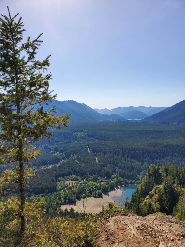
Eventually the trail arrives at a boulder field where you’ll be rewarded with open views to the southeast. Neighboring mountains in the surrounding recreation areas primarily make up the view, but on a clear day hikers can see as far south as Mount Rainier.
Most people end their hike here at the boulder field but the trail technically continues to a second viewpoint. Follow the stone steps beyond the boulders and turn at the sign for the Snoqualmie Valley Overlook. Here you’ll be able to look out to the west at views of Seattle and the Olympic Mountains.
5. Mailbox Peak
- Distance: 9.4 miles roundtrip
- Elevation gain: 4,000 feet
Mailbox Peak is one of the most challenging hikes in North Bend.
So naturally, hikers of all skill levels flock to this trail to test their limits.
The parking lot – which requires a Discover Pass – fills up over capacity on weekends. I hiked Mailbox Peak in mid-November and still had to park half a mile away, adding an extra mile of walking to this already lengthy hike.
Make sure to park at the trailhead for the newer route up to the peak. The new trail is hard enough, but the original trail is absolutely insane since it covers the same amount of elevation gain in half the distance.
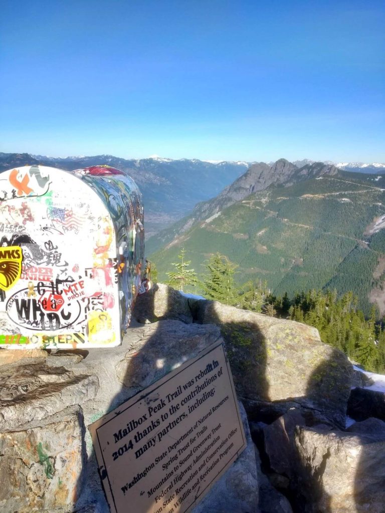
No matter which route you take, you’ll finish at the aptly-named peak which does, in fact, have a mailbox on it.
Someone once asked me, “Is there just a mailbox up there?” If the novelty of the mailbox is not reason enough for you to take on this challenging feat, don’t worry. The views from Mailbox Peak are well worth the effort.
On Mailbox Peak you’ll take in 360-degree views of snow-capped peaks. This includes views of Mount Rainier on a clear day.
You may also be visited by mountain goats while you rest on the peak.
I highly recommend bringing trekking poles on this trail. I didn’t own a pair at the time I hiked the trail (but I caved and bought a pair shortly afterwards).
Looking for more trails in Washington? Check out these related articles:
- 6 Spectacular Sunrise & Sunset Hikes Near Seattle
- 15 Spectacular Lake Hikes Near Seattle (For All Skill Levels)
- 17 Best Easy Hikes In Washington State (According To A Local)
- 18 Great Fire Lookout Hikes In Washington
- 9 Beautiful Waterfall Hikes In Washington
- 8 Fantastic Hikes On Orcas Island: A First-Timer’s Guide
- Best Easy Day Hikes In Mount Rainier National Park
As always, enjoy the outdoors responsibly. Leave no trace on all of your adventures.